Mining operations need monitoring that is safe, fast, spatially complete, and easy to integrate into daily decisions. As pits, dumps, and tailings facilities become larger and more dynamic, monitoring is no longer a periodic support task. It is part of how mines protect people, secure assets, and maintain production continuity.
Total stations deliver millimeter accuracy at selected prisms; radar is highly effective for detecting very small line-of-sight movements over large areas. RIEGL adds dense, high-accuracy 3D surface information across the entire scene. Instead of asking whether one point moved, engineers can assess which area changed, how far deformation extends, how much material was displaced, and whether the pattern matches geology, design intent, or operational activity.
A major strength of the RIEGL sensor platform is flexibility. The same instrument can be used for precise static surveying, for mobile mapping from a vehicle, and for permanent autonomous monitoring. This gives mines one consistent data framework for baseline surveys, rapid area coverage, and continuous observation.
RIEGL VZ-i scanners can run custom applications directly on the instrument, turning the scanner from a data collector into an autonomous measurement and analysis node. With the RIEGL Monitor+ App, users can define scan patterns, monitoring intervals, alarm thresholds, and areas of interest. The system then acquires data automatically, processes it onboard, and publishes results without repeated manual intervention.
A key advantage of Monitor+ is its efficient image-based representation of each scan epoch. Distance is stored with millimeter resolution and compared at pixel level, while deformation is evaluated along the local surface normal. This supports near-real-time change detection, cluster analysis, area and volume calculation, design comparison, slope assessment, and time-series evaluation through a web-based viewer.
Through the RIEGL CB23 communication box, remote access can be established via LTE, Wi-Fi, Starlink, etc., and threshold-based notifications can be forwarded directly into alarm chains and control-room workflows. That makes RIEGL relevant not only for measuring change, but for triggering action.
At the same time, the monitoring record becomes more valuable with every epoch. Because the system produces a dense, time-resolved 3D history of the surfaces, geotechnical teams can distinguish short-term fluctuations from persistent trends, local disturbances from broader deformation, and operational effects from geotechnical instability.
RIEGL complements a multi-sensor strategy by adding a complete three-dimensional surface layer to the data collected by prism and radar observations. Combining long-range performance, flexible deployment, onboard processing, web-based access, and open integration through custom applications in Python or C++, RIEGL helps mines turn monitoring from a disconnected survey task into an autonomous digital workflow – and that is exactly what a digital mine requires.
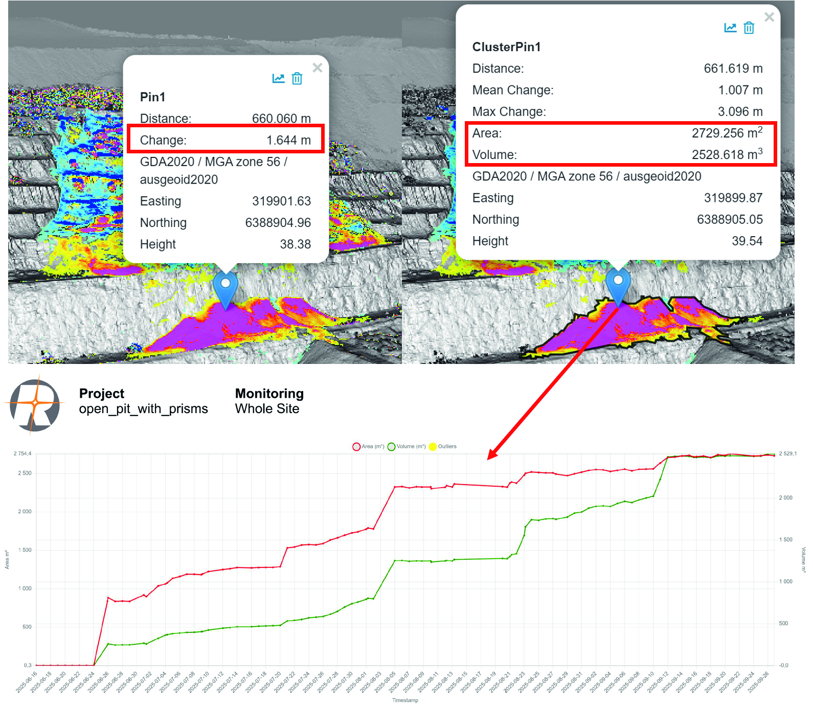
upper left – single pixel analysis shows „Change“ between 2 epochs
upper right – cluster analysis shows „Area, Volume“ between 2 epochs
bottom – diagram of cluster change over all epochs